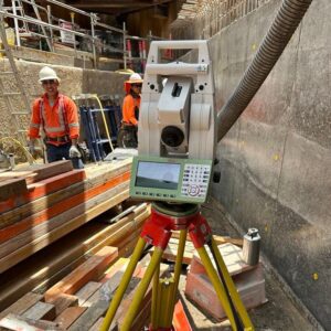
A total station is a highly advanced surveying instrument that integrates an electronic theodolite and an electronic distance meter (EDM) to measure angles and distances with precision. It is widely used in land surveying, construction, and engineering projects to collect data for creating detailed maps, plans, and 3D models.
How Does a Total Station Work?
A total station consists of a telescope, a computer, and a reflector. The EDM sends a laser beam to a target, and the instrument measures the time it takes for the beam to reflect back, calculating the precise distance. The built-in theodolite records horizontal and vertical angles, while the onboard computer processes and stores data for further analysis. Some total stations offer remote operation, GPS integration, and automated movement for enhanced efficiency.
Types of Total Stations
Manual Total Stations
Manual total stations require a surveyor to aim and record measurements manually. They are cost-effective, easy to use, and ideal for smaller projects but are slower and more prone to human error compared to robotic models.
Robotic Total Stations
Robotic total stations operate with a motorized system that automatically aims and measures distances, significantly increasing efficiency and reducing the need for manual intervention. They can be controlled remotely, making them ideal for large-scale or high-risk projects.
Key Features of a Total Station
-
High Accuracy: Measures angles with precision up to 1 second of arc and distances with an accuracy of 2mm + 2ppm.
-
Automatic Target Recognition: Locks onto a reflector for fast and accurate measurements.
-
Onboard Data Storage: Stores and processes data for easy transfer.
-
Remote Control Capability: Allows measurements to be taken from a distance.
-
Software Integration: Supports data processing and 3D modeling.
Applications of a Total Station
-
Construction: Site layout, foundation positioning, and building alignment.
-
Engineering: Road, bridge, and infrastructure planning.
-
Land Surveying: Topographic, boundary, and cadastral surveys.
-
Mining: Tunnel alignment and resource mapping.
-
Archaeology: Mapping ruins and measuring historical artifacts.
Advantages of Using a Total Station
-
Efficiency: Combines multiple surveying tools into one, reducing equipment needs.
-
Versatility: Suitable for diverse surveying tasks.
-
Reduced Human Error: Automated functions improve accuracy.
-
Cost-Effectiveness: Saves time and labor in large-scale projects.
Advancements in Total Station Technology
-
Reflectorless Total Stations: Measure distances without a prism, useful for inaccessible locations.
-
3D Scanning Total Stations: Capture 3D point clouds for detailed modeling.
-
Wireless Connectivity: Bluetooth and Wi-Fi integration for real-time data transfer.
-
GNSS Integration: Combines GPS data for enhanced accuracy.
Total Station Accessories
-
Tripods: Provide stability for accurate measurements.
-
Prisms: Improve reflection and accuracy.
-
Data Collectors: Store and transfer collected survey data efficiently.
The Role of Total Stations in Modern Surveying
Surveying has evolved from ancient measurement techniques to cutting-edge technology. The total station is now an essential tool in land surveying, providing high accuracy and efficiency for professionals. Whether for construction, engineering, or research, total stations continue to revolutionize the way land is measured and mapped.
At VIC Feature Survey, we utilize the latest total station technology to deliver precise and reliable surveying solutions tailored to your project’s needs. Contact us today to learn more about our services!
Useful links: